

Lot n° 53
Estimation :
100 - 150
EUR
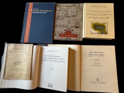
(Cartography - Portolan Charts) - 6 volumes - Lot 53
(Cartography - Portolan Charts) - 6 volumes
- KUPCIK (Ivan). Munich Portolan Charts “Kunstmann I-XIII” and Ten Further Portolan Charts. Munich and Berlin, 2000. Folio, 176 pp., publisher’s cloth binding. “A revised and supplementary new edition of Friedrich Kunstmann’s original work of 1859 with 13 rendered color plates and ten additional early 16th-century sea charts from the Munich Portolan Charts collections, including those missing since 1945”. Bilingual German-English edition. The 23 color plates are spread across two pages. Bibliography. Index.
- *The World Encompassed*. An exhibition on the history of maps held at the Baltimore Museum of Art, October 7 through November 23, 1952. Baltimore, 1952. In-4, XIV, [63 ff], LX plates, paperback, illustrated cover. Exhibition catalog describing 282 maps or atlases and reproducing a large portion of them in 60 plates.
- GRAVIER (Gabriel). Toscanelli’s Letter and Map to Fernam Martins and Christopher Columbus. Based on Henry Vignaud. Rouen, Caniard, 1902. In-8, 23 pp., paperback. Offprint.
- WAGNER (Henry Raup). The Cartography of the Northwest Coast of America to the Year 1800. University of California Press, 1937 (Reprint, 2002). 2 volumes in one in-4 volume of XI, V, 543 pp., publisher’s cloth. Illustrations. One of the most important works on the history of cartography in the United States. It includes a comprehensive index, a bibliography, a list of place names, and maps. The descriptions of significant maps are accompanied by an analysis. See: Ristow, Guide to the History of Cartography No. 377. Fold-out maps included separately.
- COUTO (D.) et al. Historical Atlas of the Persian Gulf (16th–18th Centuries). Turnhout, 2006. In-4, 490 pp., publisher’s illustrated hardcover. “The Historical Atlas of the Persian Gulf is a joint initiative of the École pratique des hautes études (Paris), the University of Tehran, and the Documentation Center of the Iranian Ministry of Foreign Affairs. The aim of this trilingual publication (French, English, and Persian) is to trace the evolution of representations of the Gulf between 1500 and 1750.” 150 reproductions of maps and portolans, half of which are in color. Extensive index.
- SKELTON (R. A.). Decorative Printed Maps of the 15th to 18th Centuries. A revised edition of: Old Decorative Maps and Charts by A. L. Humphreys. London and New York, 1952. Folio, VII, 80 pp., 84 plates (some in color), publisher’s red cloth Bradel binding.
My orders
Sale information
Sales conditions
Return to catalogue