

Lot n° 34
Estimation :
300 - 400
EUR
Résultats sans frais
Résultat
: 400EUR
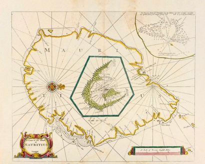
THORNTON, John. A
Chart of the Island of Mauritius. Londres, ca. 1734. Col. Pâles mouillures en bas de carte, 2 infimes petits trous de ver. Bel exemplaire sur papier fort. 435 x 535 mm. Carte publiée dans The English Pilot, the Third Book mais il s'agit ici d'une édition ultérieure, avec le nom et l'adresse grattés, peut-être par William Mount & Thomas Page, (1734). Carte coloriée avec un médaillon figurant Port Louis. A rare and unusually detailed chart of Mauritius, orientated with north to the right, with inset charts of Port Louis Harbour and the St Brandon's Shoals. Published in The English Pilot, the Third Book, the first English sea atlas dedicated to navigation to the East Indies.
Mes ordres d'achat
Informations sur la vente
Conditions de vente
Retourner au catalogue